
Tools & Resources
Seeking expertise for business challenges or access to specialised equipment and facilities? Our Centre for Water and Spatial Science provides solutions focused on your needs and priorities, delivering tangible, evidence-based results.
We have established a centre with a rich history, legacy, and a proven record of successful delivery. We've assembled individuals with a remarkable history of effective collaboration and delivering high-quality work.
On this page
Consulting services
Are you seeking expertise to address a business challenge or boost your business capabilities? Do you require access to specialised equipment and spaces, such as laboratories and facilities?
At the Centre for Water and Spatial Science, we utilise our knowledge to provide solutions for your business problems. Our focus is on your needs and priorities, and we are committed to delivering tangible, evidence-based results.
Infrastructure & Decision Tools

AED: Aquatic EcoDynamics
The AED research group studies the functional interrelations between hydrology, biogeochemistry, and biota to predict the response of inland and coastal waters to local and global pressures.
The General Lake Model (GLM) is developed as a freely available open-access tool to improve our knowledge of how changes in land-use, climate and management actions will affect our freshwater resources and lake ecosystems.

APPN Australian Plant Phenomics Network
The Australian Plant Phenomics Network (APPN) is part of Australia’s National Collaborative Research Infrastructure Strategy (NCRIS). The NCRIS-enabled APPN is a distributed network of national research infrastructure platforms offering open access to state-of-the-art plant phenomics technologies, tools and expertise, used by academic and commercial scientists.

Boyagin OzFlux Tower Site
The Boyagin flux station is located approximately 12km west of Pingelly, near Perth, Western Australia. It was established in September 2017 and is managed by The University of Western Australia.

Canopy Resilience Project
The Canopy Resilience Project, led by UWA's Centre for Water and Spatial Science, unites scientists and communicators to monitor Perth's urban trees, study their response to climate changes, and promote sustainable green space management. The project employs satellite data, citizen science, environmental monitoring, and community outreach to achieve its goals.
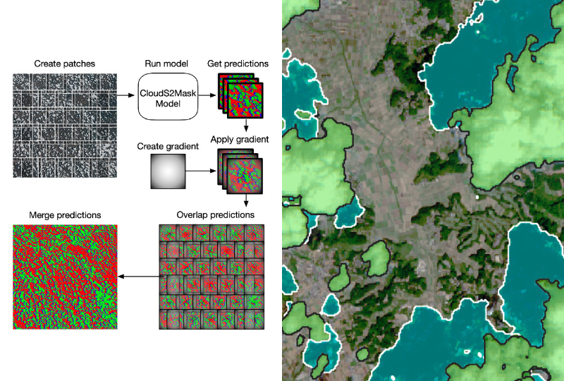
CloudS2Mask
CloudS2Mask, a new and open-source Python deep-learning library to detect cloud and cloud shadows in Sentinel-2 data accurately and efficiently. CloudS2Mask is trained on multiple large global datasets including CloudSEN12, KappaSet, Sentinel-2 Cloud Mask Catalogue, Sentinel-2 reference cloud masks generated by an active learning method and a custom CloudS2Mask dataset.
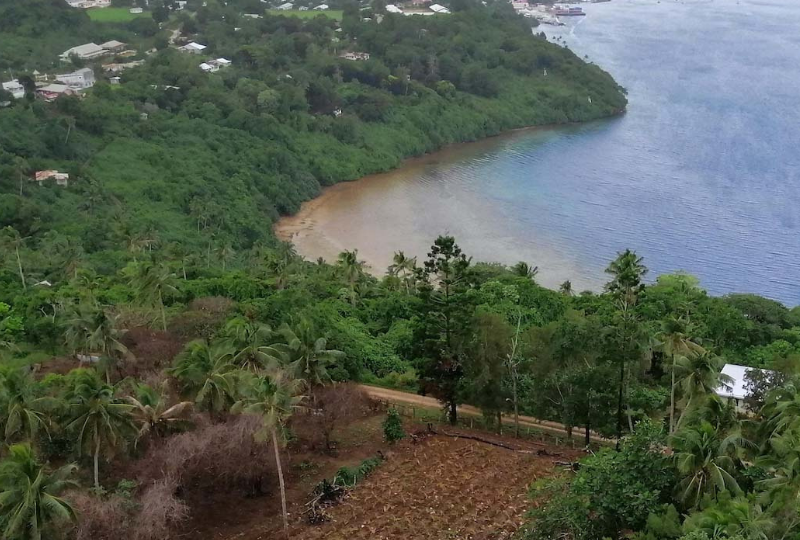
Fiji Livelihoods and Landscapes
maplandscape is a stack of open-source applications for mapping and monitoring diverse agricultural landscapes. The workflow can be used for geospatial and non-spatial data collection tasks, large team data collection efforts, rapid mapping after disasters, and household surveys for monitoring programs and projects. It is developed by a collaboration of agricultural landscape stakeholders and spatial scientists in Tonga, Fiji, and Australia.

General Lake Model
General Lake Model (GLM) is a 1-dimensional lake water balance and stratification model. It can also be coupled with a powerful ecological modelling library to support simulations of lake water quality and ecosystem processes.
GLM is suitable for a wide range of natural and engineered lakes, including shallow (well-mixed) and deep (stratified) systems. The model has been successfully applied to systems from the scale of individual ponds and wetlands to the scale of Great Lakes.
For more information about running GLM, please see the model website's scientific basis description and the GLM workbook.
GLM-py
glm-py is a Python interface for the General Lake Model (GLM) and is an open source project that is actively maintained by the Aquatic EcoDynamics research group at the University of Western Australia
✔ Translating user-friendly web inputs into technical instructions understood by GLM
✔ Streamlining workflows for researchers and students, enabling them to prepare inputs, run simulations, and visualise results entirely within Python
In this short video, the developer of GLM-py walks through its capabilities and demonstrates how it was applied in the WaterSmart Dams: Making Dams Work Again project

Hot Cities
Using machine learning to map residential property-parcel scale (re)development across Australian cities and measure its impact on built, impervious, and tree cover. Using a combination of thermal remote sensing and microclimate models, we're assessing how (re)development has warmed Australian residential areas and identifying types of development that increase or reduce heat exposure. A detailed analysis of existing planning and policy processes will be undertaken to assess their effectiveness for controlling heat-causing (re)development.

ICoAST: Integrated Coastal Analyses and Sensing Technology
ICoAST will develop and apply a suite of tools and methods to improve monitoring and current understanding of ecological and physical processes in north-west WA including Gutharraguda, and the Gascoyne and Perth regions.

More than Maps
More Than Maps is to enable student's to use state-of-the-art geospatial techniques to understand climate change impacts on our coastlines. We've developed a series of workshops that demonstrate how you can combine satellite images, geospatial technologies, and socio-economic data to identify the fingerprint of climatic hazards on coastal regions and strategies to adapt to these challenges.

OzCZO: The Australian CZO network
Australian Government funding is enabling research into Australia’s critical zone—Earth’s outer skin, from treetop to bedrock, where water, atmosphere, ecosystems, soil and rock interact—to better understand and manage the availability of its life-sustaining resources.

Recharge Estimation Collaboration & Recharge in a Changing Climate
The Recharge Estimation Collaboration and Recharge in a Changing Climate projects established seven recharge monitoring observatories around the Swan Coastal Plain providing data on depth to groundwater, soil water content across the soil profile, lithology, soil water potential, electrical resistivity along two dimensional profiles and local meteorology. Data are stored at the Department of Water and are available on request.

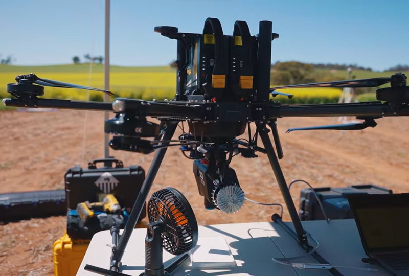
Remotely Piloted Aerial Sensing Platform
UWA's Remote Aerial Sensing Platform provides operational infrastructure, expertise, support and advice for drone and environmental sensing. The facility provides the capacity for research collaboration, brings expertise and licencing to a UWA research group, and makes drones, sensors and other equipment available for other external projects.
Flying Drones at UWA Learn More

WaterSmart Dams
The WaterSmart Dams project involves 12 core demonstration sites, building farm-based water planning tools, workshops, field days and industry training. The project is investigating solutions including renovating existing dams, building new dams, and implementing evaporation suppression and runoff technologies. The Centre for Water and Spatial Science at UWA has developed the Water Evaluation Platform (WEP) – a key component of this project.
Water Evaluation Platform
The Water Evaluation Platform (WEP) is an online platform for evaluating water security on farms, enabling users to adequately size catchments and dams to meet their water needs and understand the economics of different water security options.
The WEP was designed with industry experts and growers and supports individual farms, private contractors, water planners, and local communities to make drought-resilient investment decisions.
Laboratory Facilities

Water Laboratory (G16-G18)
The UWA Water Laboratory, situated within the School of Agriculture and Environment (SAgE) in the Geography/Geology building at the Crawley Campus. A facility equipped with a wide range of water quality and sediment quality sampling equipment.
Field Electronics Lab (B.07)
The Laboratory, is situated within the School of Agriculture and Environment (SAgE) in the Geography/Geology building at the Crawley Campus. The laboratory is equipped with a diverse range of cutting-edge tools and equipment, including drones, field instruments, 3D printer, and electronic devices.
Earth and Environment Analysis Laboratory (EEAL)
UWA's Earth and Environment Analysis Laboratory (EEAL) is located within the UWA School of Agriculture and Environment (SAgE). An array of analytical techniques and services including nutrient analysis of soil and water, elemental analysis of soil, water and plant material, geochemical analysis, particle size analysis and acid-sulphate soil assessment using modern instrumental techniques.
Find an expert
Contact us or search the UWA profile database to connect with our network of researchers, who are experts in their field.